
Following Red River Scramble 2018, I’ve received a number of inquiries about adventure riding opportunities in eastern Kentucky. After several attempts, I finally finished up Mountain Springs Road (Furnace-Pilot Road) this summer and checked the Daniel Boone Backcountry Byway (DBBB) off the Moto Bucket List. This part of Kentucky is where my folks are from, and I want to share the best of the Bluegrass with like-minded off-roaders. Thus, I figured I would publish a guide so that riders of all skill levels can better navigate their way around the Byway.
The DBBB is a continuous loop around Red River Gorge and surrounding areas. For the most advanced riders, you can get on “the byway” by heading west from Slade until you intersect the route and run the loop counter-clockwise. 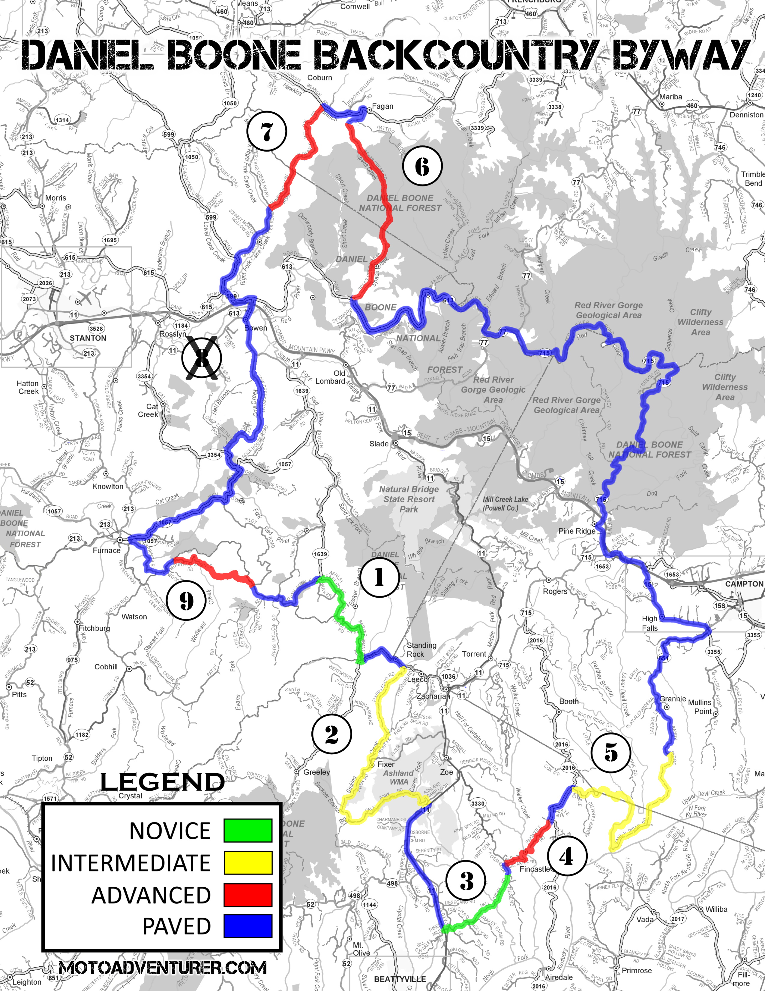 However, in the interest of “ramping up” difficulty while still riding in a loop fashion, I’m going to suggest starting just a little further south. I have created a map overlay of the DBBB, highlighting the off-road sections with a number and difficulty color code. The following descriptions speak specifically to the off-road sections, not the paved portions of the route, and reference the section numbers shown on the map. Please keep in mind, my judgment of difficulty is relative to the other sections of the DBBB; depending on what bike you are riding and your level of off-road experience, your opinion regarding the difficulty of these sections may vary. In addition to that statement, trail conditions change constantly; I have seen Pumpkin Hollow and Fincastle road in very different states depending on season and recent weather. Severe weather, combined with recent jeep traffic, can drastically change the level of difficulty of a given section; please plan accordingly.
Barker Branch Road (1)
Essentially a wide gravel highway between old oil properties, Barker Branch is an easy warm-up for folks that haven’t been off-road in a while. With large sweeping curves, the well packed gravel lets folks settle into their groove and enjoy a bit of the “clifty” scenery. This section is easily suitable for all bikes and skill levels; please note, like the entirety of the DBBB, this county road is open to two-way traffic, and you are very likely to encounter large trucks driving in the opposite direction.
Difficulty: Easy
Terrain: Hard Packed Gravel
Hazards: Vehicle Traffic
Fixer-Leeco, Lairson, Fixer, and Cave Fork Road (2)
While I really enjoy the more technical sections of the DBBB, I feel safe saying that the Fixer-Leeco string is arguably the best “bang for buck” on the DBBB. With 8 miles of all but completely unbroken gravel and dirt, this leg is also the longest continuous off-road section the Byway. Mostly gravel over hard-packed sand, the section through Fixer includes some fairly weathered but well-travelled trail, including a handful of creek crossings through more old oil property. While I consider this section “easy” under dry conditions, some of the downhill sections can become heavily rutted following summer thunderstorms. Ultimately, Fixer is a great section for newer adventure riders looking to hone their off-road skills in ruts and water before stepping up to the intermediate challenges.
Difficulty: Intermediate
Terrain: dirt, gravel, hard-packed sand, weather ruts, active creek beds
Hazards: Vehicle traffic, creek crossings, and rutted trails after heavy rainfall
Hell Creek Road (3)
A menacing name for what is an otherwise photogenic gravel road through the forest. Hell Creek Road is another well-manicured trail, which again means you need to be mindful of two way traffic, especially along the “clifty” sections. Aside from a mild creek crossing (“Hell creek”), this section is most notable for its photo opportunities under a couple of substantial cliff faces.


Difficulty: Easy
Terrain: Hard Packed Gravel
Hazards: Vehicle traffic, creek crossing, no guard rails along steep ravines
Fincastle and Old Fincastle Road (4)
While only a little over 2 miles in length, Fincastle road offers “intermediate” adventure riders a chance to test their grit. Heading downhill from Shumaker Ridge, the weather rutted trail winds along the cliff-line until it reaches the creek crossing. Walker Creek has the potential to be deep depending on season, so choose your line carefully and test the level if necessary. Potentially adding insult to injury, be prepared for the landing on the far side of the creek to be muddy from other off-roaders. Following the creek crossing, continue east “up” the hill. I don’t use the term “up” lightly, once out of the creek the trail has a steep climb up to a rock shelter, including a hairpin in the midst of slick clay and loose rocks. Once at the rock shelter, there’s another good photo op at the base of the rock field, which is arguably the most difficult part of Fincastle road; folding shift pedals and a good skid plate are recommended…
Difficulty: Advanced
Terrain: Gravel, creek crossing, large loose rocks, boulders, clay
Hazards: UTV traffic, deep creek crossing, 300 foot uphill rock field, slick conditions after recent rain


Big Andy, Lower Devil Creek, and Sandy Ridge Road (5)
A sweeping gravel farm road; stay alert on Big Andy road for locals headed back into town. Once you pass a large assembly of old oil equipment, you start down Lower Devil Creek Road. The largest water crossing on the DBBB, you end up crossing Lower Devil Creek up to three times; depending on recent weather, these creek crossings can also be considerably deep. Once on the east side of Lower Devil Creek it’s a scenic creek-side dirt road until the uphill gravel on Sandy Ridge Road and on toward Campton.
Difficulty: Intermediate (Advanced during high water conditions)
Terrain: Gravel, dirt
Hazards: Vehicle traffic, lengthy creek crossings
Spaas Creek Road (6)
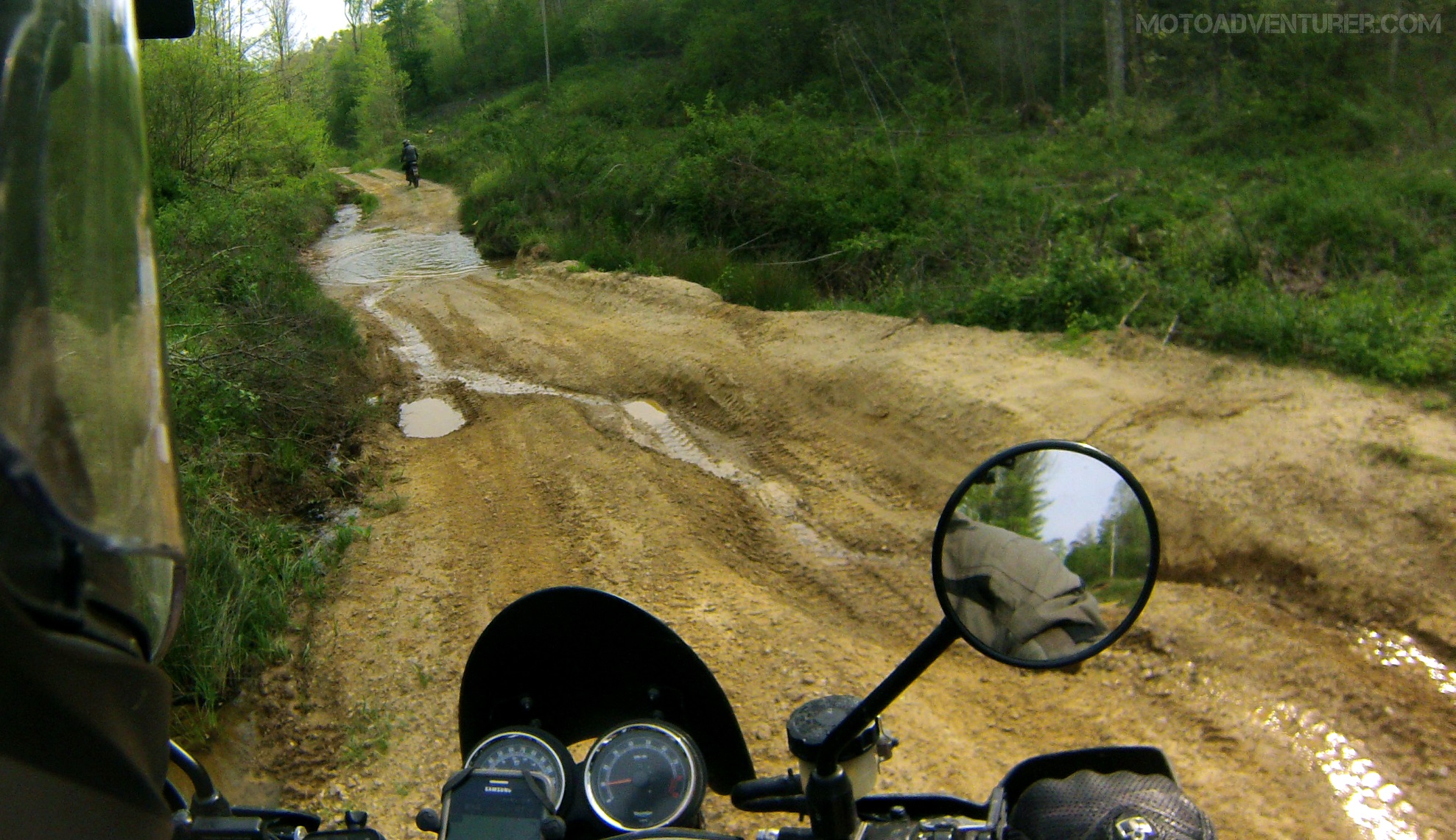
Looking to improve your mud riding skills? Here’s your chance. Spaas Creek road was my first exposure to the DBBB, a road I vowed to conquer. About 5 miles in length, Spaas creek lures you in with a 2 mile stretch of pristine gravel forest road, before you’re abruptly thrown into a dark muddy creek valley. Of all of the sections of the DBBB, Spaas Creek is probably the most featured on YouTube, for good reason; with over 12 creek crossings, you’ll quickly discover the creek bed is firmer than the trail. While still a legal county road, vehicle traffic outside fellow DBBB adventurers is possible but unlikely. Folks with lighter dual-sport bikes should enjoy the terrain thoroughly, heavier ADV riders would be wise to bring aggressive tires as the trail is typically quite damp regardless of season.
Difficulty: Advanced
Terrain: Gravel, dirt, mud, creek beds
Hazards: Deep mud puddles (“Jeep Pits”), deep ruts, creek crossings, deep mud


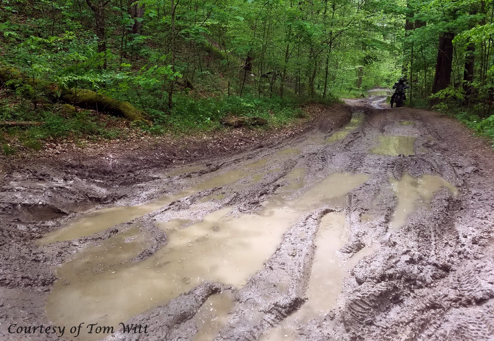
Pumpkin Hollow Road (7)
Out of the skillet and into the frying pan, after a short creek side run, Pumpkin Hollow takes you back over the ridgeline and into another creek valley following a steep hill-climb. From the mud on Spaas Creek, Pumpkin Hollow brings deeper ruts in the slick Kentucky clay. On the backside of the ridgeline, it’s more clay, dirt, and creek runs. Again, heavier ADV bikes may struggle depending on recent rains and tire selection.
Difficulty: Advanced
Terrain: Dirt, clay, creek beds
Hazards: Steep incline, deep ruts, creek crossings


Chop Chestnut Road (8)
Due to safety concerns about tourists traveling through an active quarry, Chop Chestnut Road has been removed from the DBBB. Stay tuned to this page and elsewhere for pending updates to the DBBB (edit: 2/24/21).
Passing the quarry you quickly transition from gravel to sand and sandstone ledges. A little over a mile in length, this section gives riders mild exposure to loose sand depending on recent rainfall, along with larger rock obstacles, including a significant skid-plate testing downhill “stair case“. “Jeep pits” can be somewhat of a problem depending on recent weather; be mindful that many of the puddles may be significantly deeper than they appear.
Difficulty: Intermediate
Terrain: Sand, Sandstone
Hazards: Unsuspecting deep sand, slick sandstone, deep puddles, sandstone “staircase”
Furnace-Pilot Road (9)
As the pavement of Mountain Springs Road ends at what looks like a farm driveway, Furnace-Pilot road begins (ride east through the “gate” and past the barn and continue along the GPX route, this is a legal county road). About 2.5 miles in length, Furnace-Pilot road is the culmination of the previous three sections, the most challenging section of the DBBB. Combining the mud, clay, and sand, the trail provides plenty of excitement with a “loamy” soil that makes the depth of the mud especially deceiving. Despite the short off-road section, there are a number of elevation changes made more difficult by deep ruts made by Jeep traffic. In the valleys, riders must be very cautious circumventing some of the largest Jeep pits on the DBBB, as the mud is easily 3 feet deep in some locations. Novice off-road riders and heavy adventure bikes will likely experience extreme difficulty on this section.
Difficulty: Advanced
Terrain: Dirt, Mud, Clay, Loam
Hazards: Sizable Jeep pits, significant Jeep ruts, deep mud, rock shelves.


I’ve mentioned multiple times elsewhere, the DBBB is probably my absolute favorite place to ride. Considering the local topography, and vast differences in terrain, this short 100 mile loop offers a wide range of challenges for adventurers. 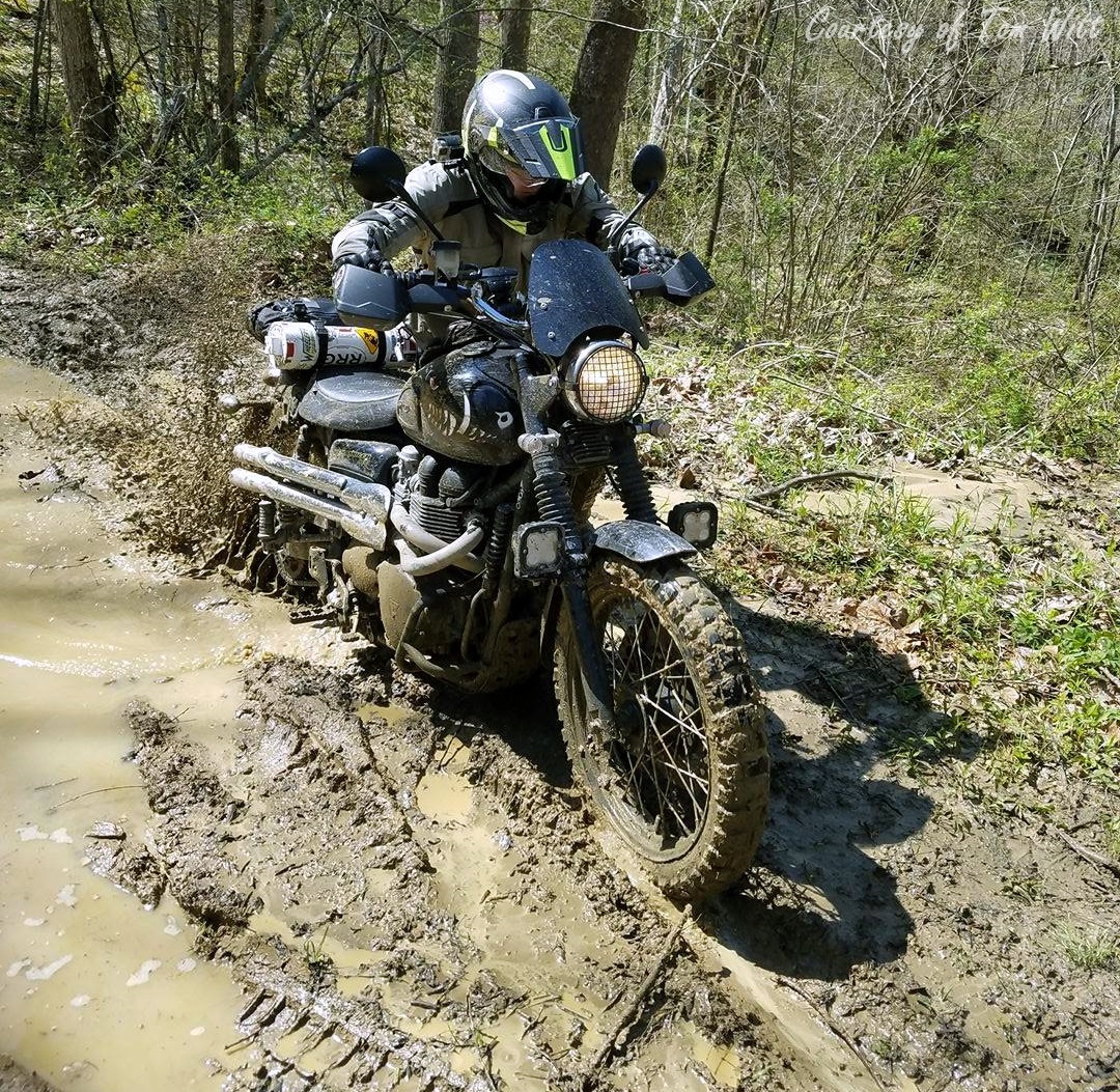 With regard to difficulty, between what I have seen in Ohio, Pennsylvania, North Carolina, and Tennessee, the DBBB has the most difficult obstacles I have faced (with exception of log crossings). The difficult obstacles on the DBBB are arguably “shorter” than the obstacles I saw at Conserve The Ride, however, the challenges in Kentucky are more technical or larger in scale while shorter in distance. I was worn out by Option 6 in Pennsylvania, but I have literally turned around more than once in Kentucky. With regard to time, the winner of this year’s Bluegrass Scavenger Hunt at Red River Scramble finished the DBBB in 5.5 hours on a CRF250L. I, however, have yet to finish an entire trip around the loop in one day on a Triumph Scrambler, and to my knowledge, the riders on larger ADV bikes at Red River Scrambler this year, also did not finish the full loop. To quote the cliché, “Your mileage may vary”…
I want to reiterate that the DBBB has been successfully traversed by yours truly on a hipster-street-fairing-novelty bike. Judicious use of the throttle and brake will get you through most obstacles, and a gnarly set of knobbies will cure a lot of ills. That said, Mother Nature is unforgiving; trail conditions change day-to-day, and even hour-by-hour in some cases. Heavy Jeep traffic is easily more destructive than heavy rain, making spring trail conditions especially challenging from what I’ve seen. When out on the trail, I always recommend using the buddy system, pack a worthy tool kit, snacks, and lots of water; when in doubt, walk obstacles before riding them, and don’t be ashamed to bypass a section and save it for later. I want as many folks as possible to enjoy the DBBB, and come back with more friends tow the next time.
How to Measure Your Adventure Riding Skills

Pingback: Ride Your Motorcycle Every Day: Reflections on 365 Days in the Saddle · Moto AdventurerMoto Adventurer
Pingback: FAQ | Red River Scramble
Pingback: How to Measure Adventure Riding Skills | Moto Adventurer
Pingback: Finishing the DBBB: Working the Moto Bucket List | Moto Adventurer
Pingback: Red River Scramble 2019: News and Updates | Moto Adventurer
Thank you for sharing!
LikeLike
My pleasure! Lots of folks want to go on an adventure, but they don’t know what they’re getting into. Figured I could give folks a heads up. Be advised, this years heavy rain has bumped up the difficulty some, so proceed with caution on the advanced sections.
LikeLike
Is there gas stations available in between on each ride ?
I know Red bird has one been there several times.
Thanks
LikeLike
Hey Scott! There’s gas in Slade, Zoe, and Beattyville. What kind of range do you have?
LikeLike
I love the dear facts you actually contribute towards your site content. I’ll bookmark your current blog page and view all over again here frequently. We’re realistically a number of I am instructed many completely new material the following! Enjoy for the next!
LikeLike
Pingback: What’s a Dual-Sport Motorcycle? | Moto Adventurer
This is pretty awesome! I just bought a 2022 KTM adventure R and I’m wanting to try some of the trails you mentioned. I actually still ride off road and the loop I ride on my woods dirt bike is 9 miles of “soft” Enduro type stuff. This adventure thing is new to me so I’ll start out doing the easy stuff first on it.
LikeLiked by 1 person
Congrats on the new Ride Shawn, I’ve really liked those KTM adventure bikes I’ve been on. I just hit the 75% of the DBBB today. The “hard” trails are definitely a mess from the spring rain, but it’s a good time. Bring a friend and enjoy. You should also check out Red River Scramble in September.
LikeLike
Is there a downloadable map? Tks for all the work!
LikeLike
https://www.ridethedbbb.org/map
LikeLike