
Monday, September 9th: Have Knobbies, Will Travel
 Like Sunday, Monday’s weather report called for “hot and dry”; a welcome change from previous year’s Raids. At breakfast, the “Usual Suspects” were debating the best place to grab lunch. As is tradition, they wanted to ride across the Cherohala Skyway and then return across The Dragon while the weather was good and before the weekend squids arrived. That’s typically my formula as well, but with my Dad’s arrival delayed until mid-week, I decided it was time to take advantage of a fresh set of knobby tires (Motoz Tractionator Adventures for those following along at home).
The boys decided they wanted to stop and see Bald River Falls, and then grab Mexican in Tellico Plains. “Sounds good. I’ll meet you in Tellico. Don’t wait up.” I said, donning my helmet for a solo trip across the mountains.
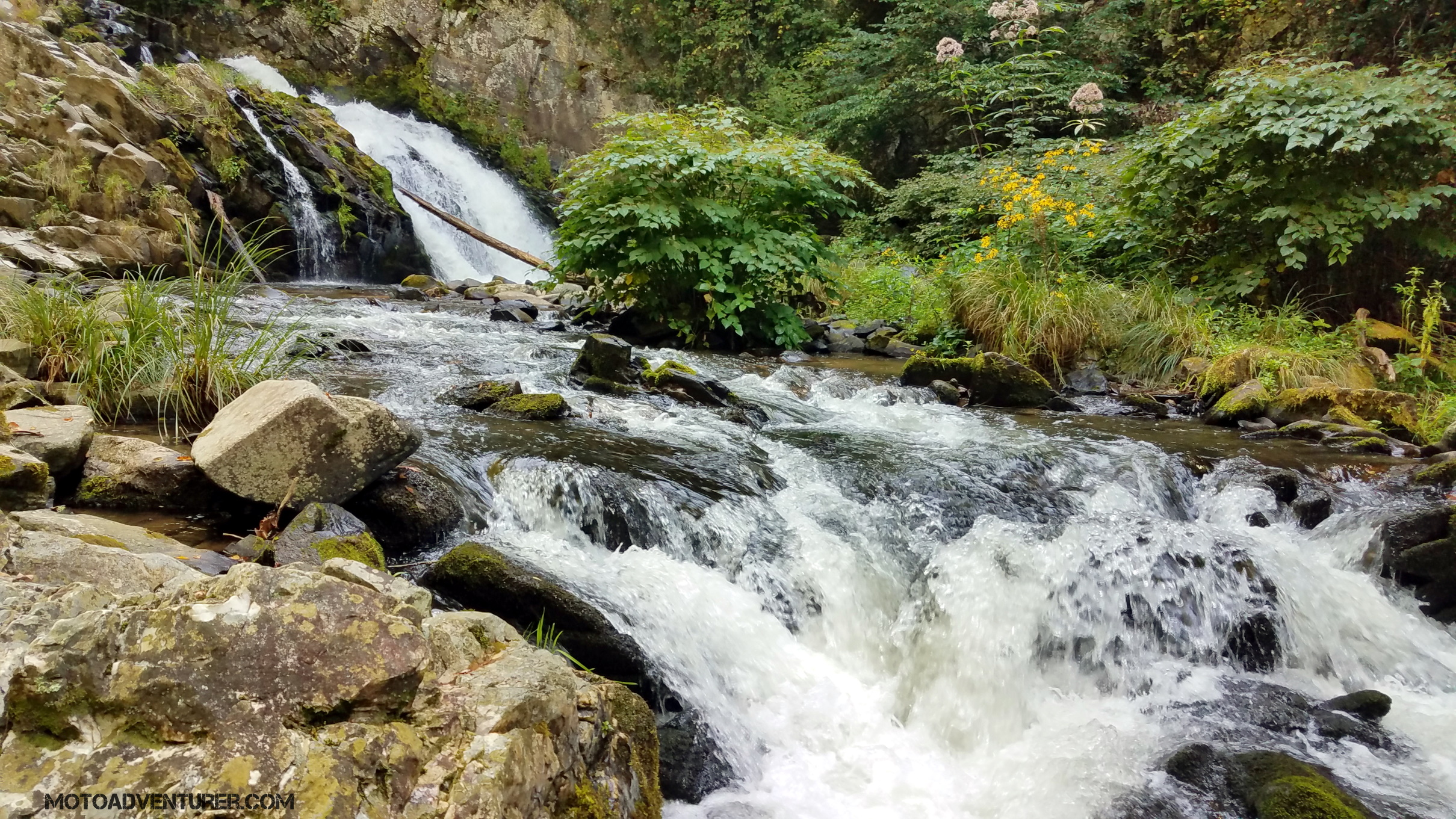
I figured if I had a twenty-minute head start I could probably get over to Tellico Plains “under” the Skyway. I mentioned a couple of years back, there’s a forest service road that starts just west of Santeetlah Lake at the base of the Skyway. 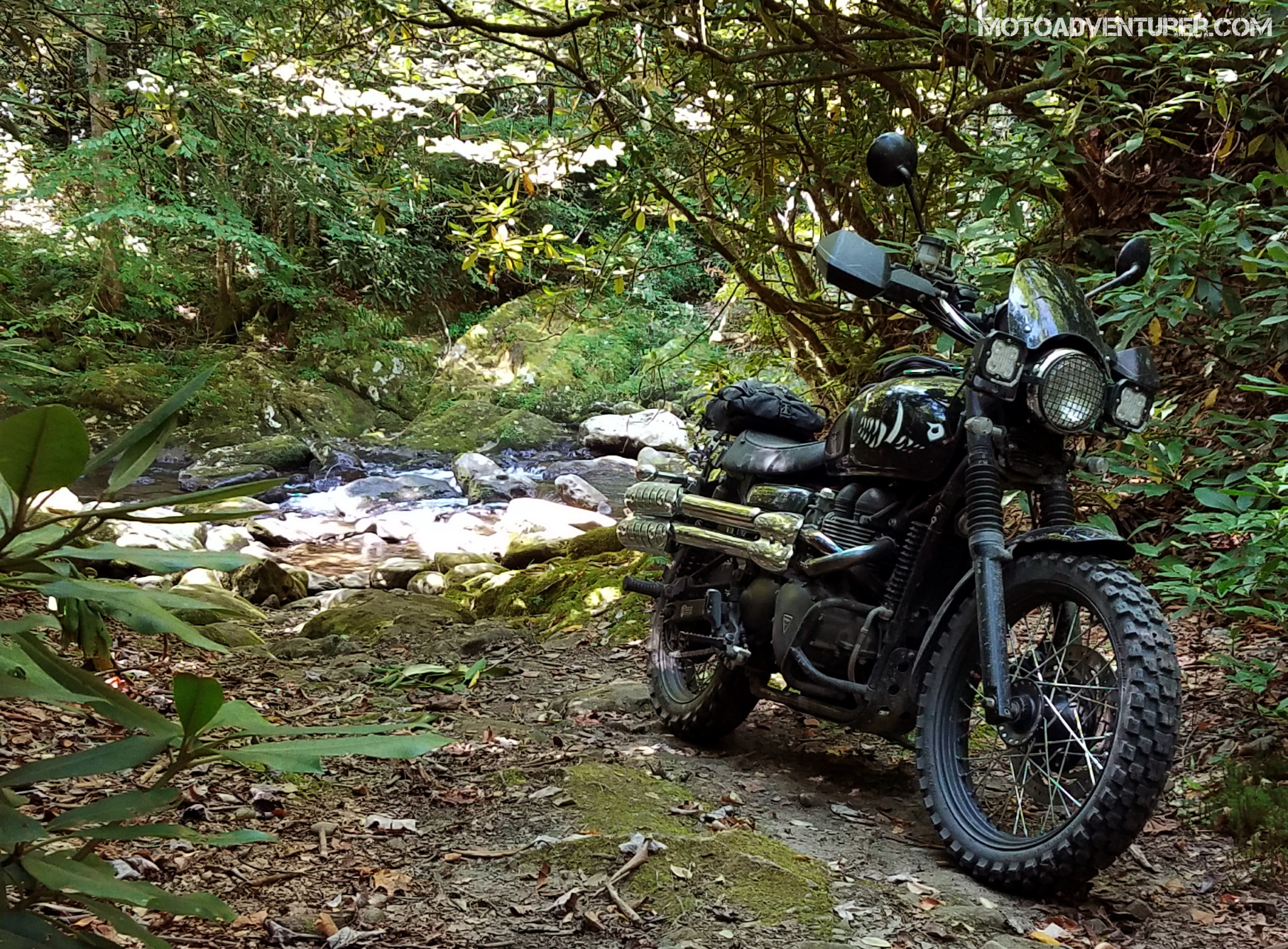 “Dragon Raiders” have often referred to this route at “GravelHala” as it mirrors the Skyway from Robbinsville to Tellico Plains; the official name of the road is National Forest Service Road 81 (NFSR) where it starts in North Carolina. As 81 winds up the mountain, there are several spots to stop, camp, and in my case take photos of boulders and white water. Just short of the Tennesse border, 81 crosses under the Skyway; at this point, you can bail off onto the pavement, or continue on to NFSR 217 (this is also “River Road”).
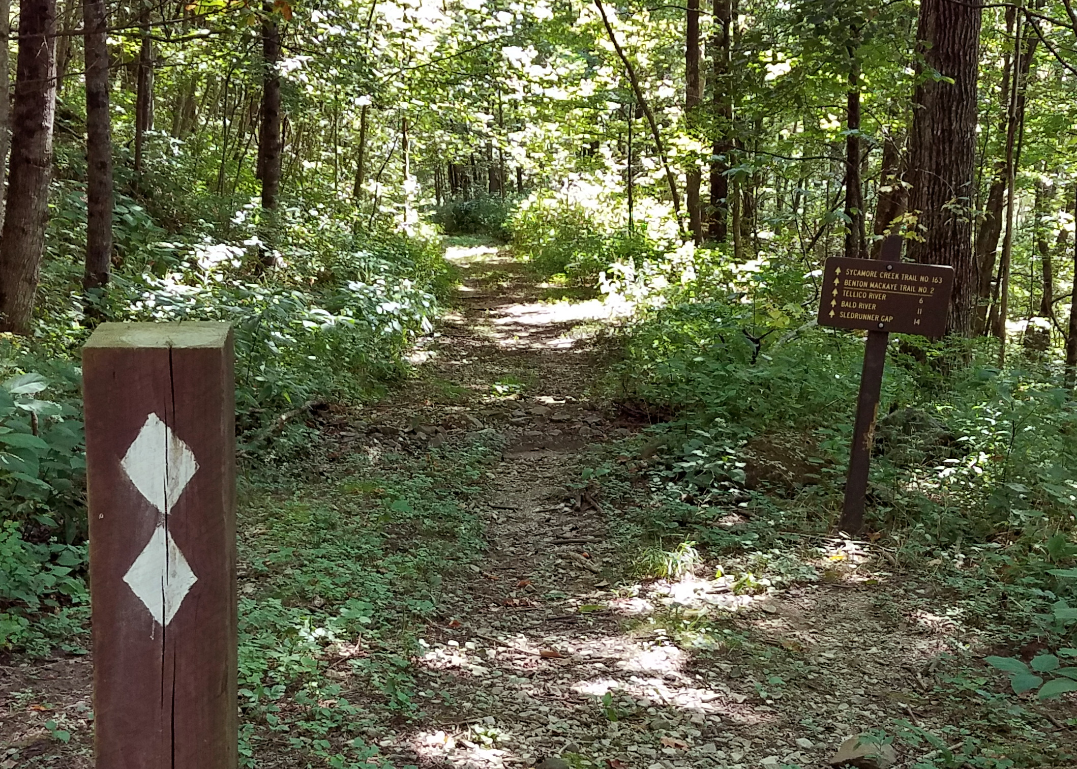 Feeling adventurous and foolishly following my GPS, I turned south off 217 and onto a road I’d not ridden in the past. The gravel narrowed as I crossed a couple of concrete bridges and after a few uphill hairpins I arrived at a sign inscribed “Sycamore Trail”. The two diamonds on the trail marker suggested that Rosie might not finish the journey if we proceded. Considering I was solo, I decided better of it. Looking around I saw the trail continued in the other direction up the mountain. After several bends up the hill and some washed-out gravel, I arrived at Whigg Meadow.
  Apparently, Sycamore Trail connects with the Benton MacKaye hiking trail (I had no idea until sitting down to write this). A gravel parking lot at the base of a bald mountaintop was the end of the road. Suspecting a grandiose photo-op, I rode up the grassy double-track to the top of the bald to investigate. The view didn’t disappoint.
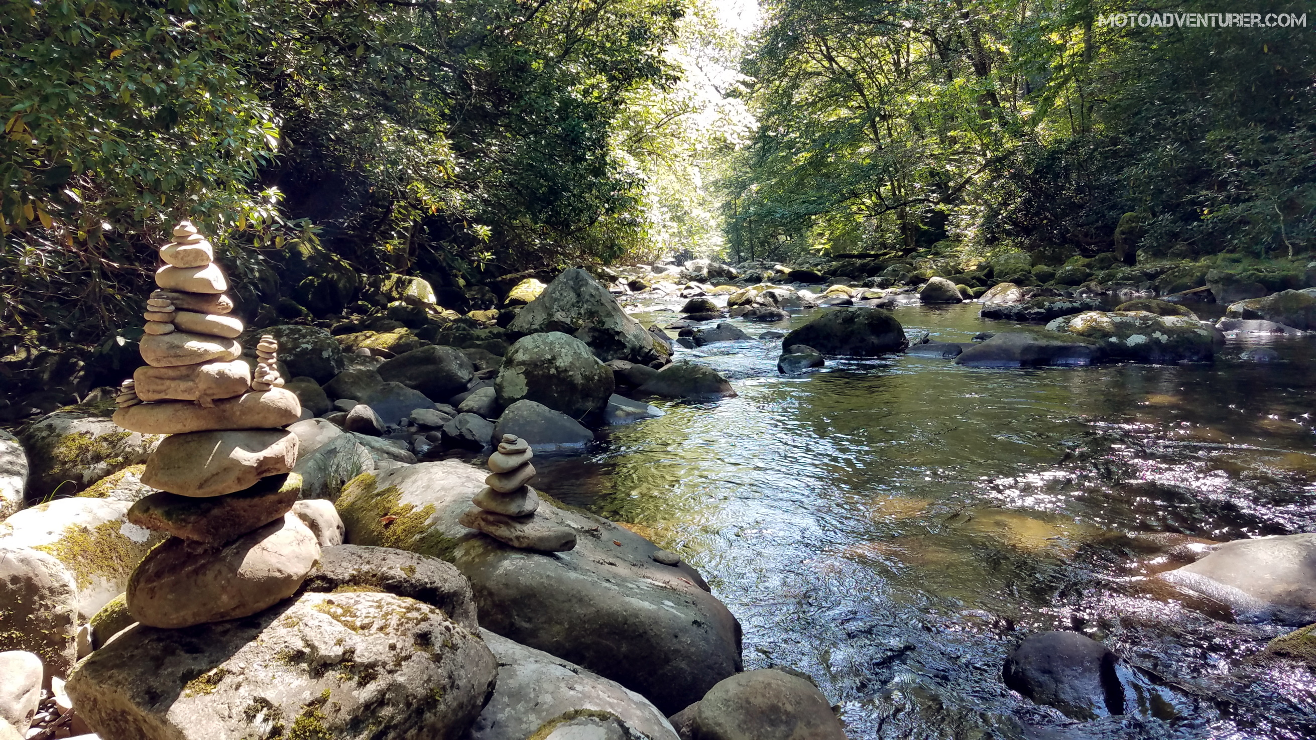
Headed back down the mountain, it was more familiar gravel to Bald River Falls. As I neared the falls’ parking area, I spotted my cohorts climbing onto their bikes after snapping some photos. Not bad timing after getting turned around and snapping pictures “for the gram“.
Sitting down for Mexican, my buddy Jon and I discussed other opportunities to ride forest service roads that link back to the Dragon. I’d been eyeballing a string of nearby “featured dirt roads” on REVER for several years, this seemed as good a time as any to figure out what they were all about.
 Headed up Rafter Road, my mind overly focused on how fast my front tire was wearing out, I was anxious to leave the hardball behind. I expected the pavement to turn to gravel at any moment, but it continued to twist up the mountain, dotted by remote farms and narrowing with each mile. Rounding another bend, the gravel finally arrived on a washboard ascent. I stood up, wearing a goofy smile of satisfaction, just in time for a Side-By-Side to rip past me in a cloud of dust.
 Near the northernmost point of the Skyway, Rafter Road meets Indian Boundary road, if you look at the map closely, you can avoid the pavement and take a short gravel bypass. Indian Boundary road continues north to Citico Creek, where the scenery is very reminiscent of NFSR 81, with more waterfalls and swimming holes.
Somewhere at elevation, I was reminded how much I love off-roading my porky Trumpet.  I’d spent much of the summer deep in the woods on the 250, leaving Rosie at home for more traditional pavement duty. The Scrambler’s suspension is less than ideal for serious off-roading, but sans pot-holes, I still love wrestling the pig on forest service roads. That thought was rudely interrupted at the first down-hill, blind turn. An Africa Twin appeared out of no-where, completely in my “lane”, naturally. To my surprise, this particular adventure rider had two other bikes in tow; each of whom also decided to cut the corner in similar fashion. Having just passed a forest service pick-up just moments prior, I was fortunately on the far right side of the road, but no less annoyed.
Monday Map: https://a.rever.co/embed/rides/768052
Tuesday, September 10th: All the Switchbacks
At last year’s Raid, I had big plans to go ride some forest service roads I’d never seen before. Naturally, I had a mixup on the GPS with the massive library I brought along. Fortunately, it still made for a fun, yet paved, backcountry two-lane experience. With another hot and dry day on tap, I set out to rectify my previous mistake, with the help of more tips from my buddy Jon.
Just west of NC-28, arguably my favorite pavement in these parts, Needmore Road turns into a gravel highway that circumvents the Franklin traffic. Albeit, not too much, I passed quite a few trucks headed the other way; “highway” is definitely an accurate term considering the dirt was packed down harder than asphalt, minus the bike swallowing potholes.
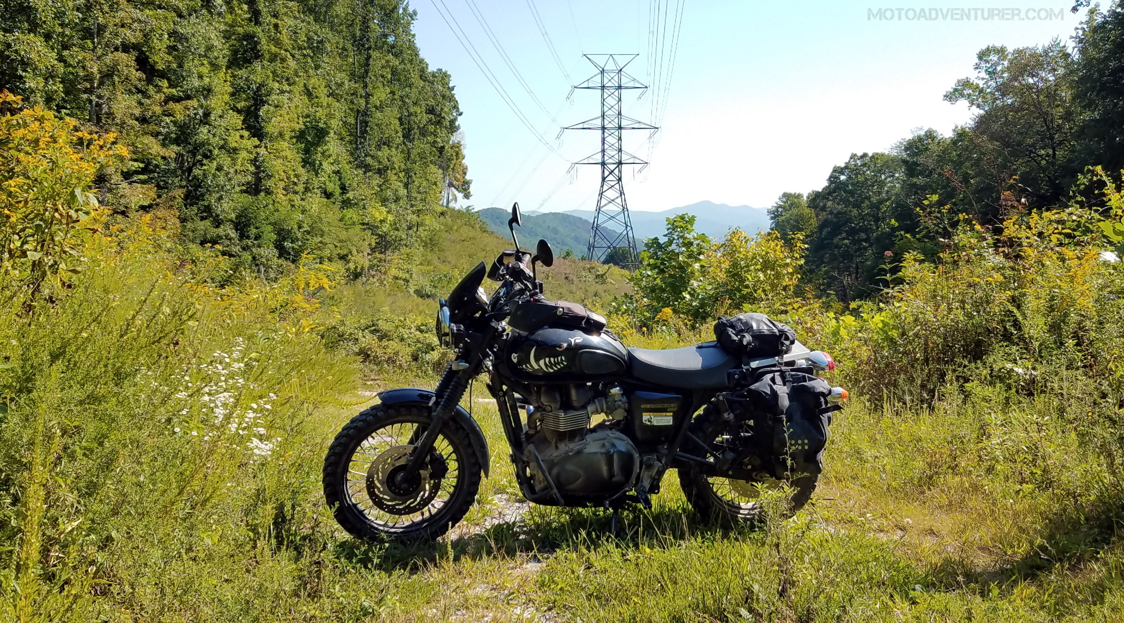 Needmore dumped me off on to some remote pavement that was oddly familiar from the previous year’s ride. Shortly after I found myself at the base of a mountain, staring up at miles of power line easement, cross-crossed by endless gravel switchbacks; Tellico Gap. A lot of dust, handfuls of throttle, and power slides were involved. When I finally arrived at the pavement on the far side, my face hurt from smiling.
 From Tellico Gap, it was Junaluska Road over the mountain into Andrews in search of Tatham Gap. Much like Tellico Gap, Tatham launched an onslaught of up-down switchbacks from the get-go. Tatham proved to be exactly the kind of riding I was looking for at the onset of the day, albeit, I could have done without all the washboard from the routine grading.
Near the summit, I saw a roadsign marked with “Tatham Gap” and a side road that I immediately took in the interest of exploring. This side road made for less maintained gravel and rock, which eventually led to Joanna Bald. “Allegedly”, there was a gate and a cell tower at the summit, so I (allegedly) didn’t hang around long. A shame really because there was apparently a fire tower just out of view. A photo-op I’ll have to revisit.
With the heat well in the 80s, I stopped at shady a creek in the fork of the mountain for lunch. A bottle of water and a couple of cliff bars is hardly “lunch”, but I live for the solitude and comfort provided by Appalachia. A quiet break in the woods next to running water, the cool mountain air and the sounds of the bird song. That’s exactly what adventure riding is all about. Assuming I’m not eaten by a bear (more on that later).
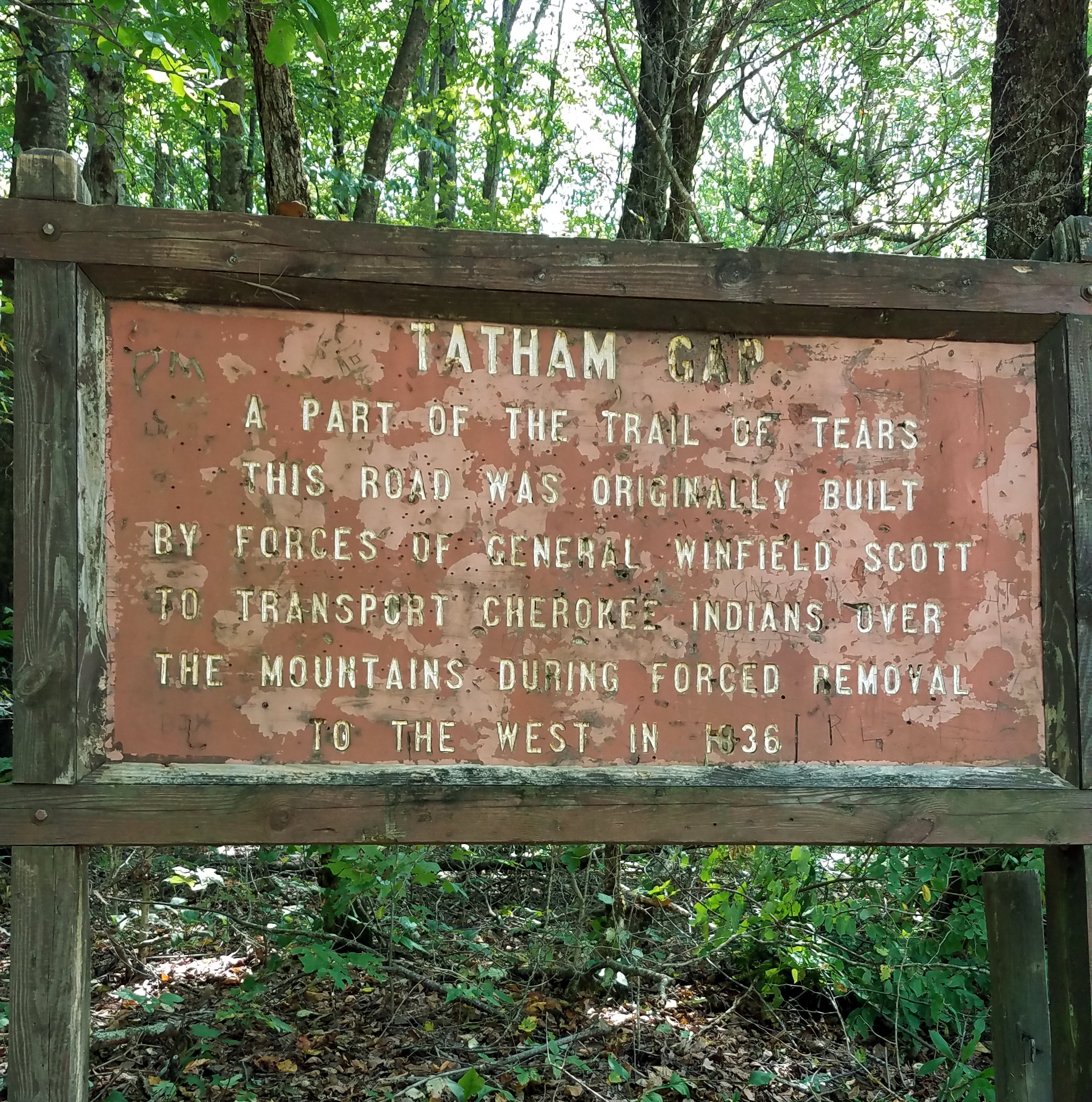
Returning to the fork in the road I stopped to read the sign I barely glanced at on the way up the mountain. “Tatham Gap Road: A Part of the Trail of Tears…”. Naturally, I snapped a photo of the sign and took a mental note to do some reading on the significance of the road. I’d heard the story of “trail of tears” before but didn’t entirely understand how this part of North Carolina played a part (how the American Indians were displaced was typically breezed-over in midwestern schools when I was a kid). While I don’t have any paperwork to prove it (nor would you assume when looking at me), legend has it my Grandmother’s Grandfather was a full-blooded Native American. Needless to say, my interest is typically peaked where my heritage is concerned (even if it’s fictitious).
Sitting down to write this, I finally caught the backstory of Tatham Gap. Long story short (kind of…), in 1836, General Scott (US Army) hired James Tatham to blaze a trail from Fort Montgomery (Robbinsville, NC) to Fort Delaney (Andrews, NC). Ultimately the US Government displaced the native Cherokee from their homes in these parts, Tatham Gap Road being the first leg of their journey toward Oklahoma (More on that HERE and HERE.)
On the far side of the mountain, I arrived in Robbinsville just after lunch hour. Realizing my proximity to “The Hub“, I couldn’t resist the thought of a grilled cheese sandwich on Texas toast, with bacon and a cup of soup. Second lunch is a thing, and it was glorious.
Sitting at the booth I realized I still had several hours of daylight to burn, so I started poking around the map for more dusty byways. Since the weather was nice, I wanted to get back up to Wayah Bald for a photo. The lightbulb lit up as I recalled a route from my buddy Walter.
Departing Robbinsville I headed southwest toward the Snowbird mountains. A couple of dual-sport guys I spoke with at breakfast said they were riding out that way, and mentioned they were hitting trails that, while they’ve ridden them on Tigers in the past, didn’t want to wrestle pigs across anymore. With that in mind, I expected to make another hasty u-turn at any moment. After miles and miles of desolate double-track (minus one Subaru), I apparently took a different route as that U-turn never arrived.
I love switchbacks and hairpins; on-road or off-road, love them both. That said, Porterfield Gap Road took me to about my limit for switchbacks and boney forest service trails. “Pinching” the tank on a Scrambler is much easier said than done with those lovely high-pipe headers. Doing so in adventure pants gets tiresome after about 4 hours; I missed my more motocross friendly gear pretty bad by the time I returned to the tarmac.
 On the far side of Portfield Gap, I again found myself in Andrews, again over Junaluska Road, and finally up to Wayah Bald. Parking the bike I thought I heard the sound of a low roll of thunder, but the view was exactly what I was looking for. Big fluffy clouds to add depth to the Smoky Mountains, and enough shade to escape the humid afternoon. Off in the distance, I did indeed see rain falling in Robbinsville. It was time to going before I had a repeat of last year.
After another trip across Tellico Gap Road (even more wheel spin was involved) and a glorious (alleged) ride down Winding Stairs, I topped off the Scrambler and it was back to the Iron Horse. Wednesday was the long trip back to Dayton to pick up my dad. A full day of pavement would be a big change from two, 200-mile back-to-back days of Appalachian adventure riding.
To Be Continued…
2020 Dragon Raid Part 3

Tuesday Maps:
https://a.rever.co/embed/rides/1495140
https://a.rever.co/embed/rides/1495525


